digital mapping
Shaping the Future of Deathcare
Customer feedback shapes deathcare provision as we transition to 2024 in the cemetery and crematorium industry.
In the first in a new series, we look at five reasons in five minutes why PlotBox is the best mapping solution for your cemetery.
We're eager to discover more about your cemetery and explore the possibilities of integrating PlotBox seamlessly into your operations.
Let's Talk| Read time: 5 mins
Five in Five is a new series shining a light on the PlotBox innovations helping to change the global deathcare landscape.
As it’s where we started, let's begin with mapping.
With that in mind, here are five reasons in five minutes why PlotBox is the best choice of cemetery mapping solution for your operation:
Headed by our Engineering Manager, our mapping team consists of no less than 26 GIS Technicians, operating at various levels within the business.
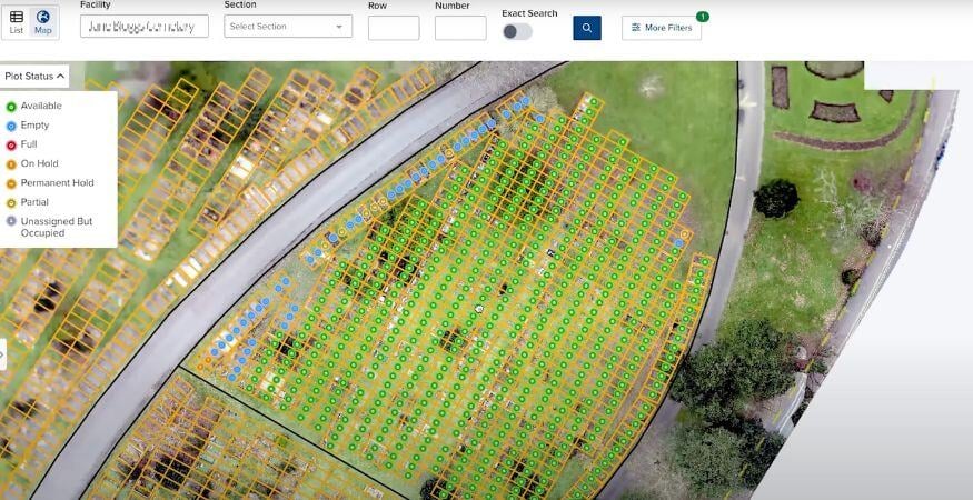
Geographic Information Systems (GIS for short) use technologies to capture and manage geographical data, allowing us to create highly detailed, layered cemetery maps.
When linked to deceased records, this gives you unparalleled visibility and control over your inventory, meaning greater accuracy, less risk, more sales, better planning, and greater efficiencies.
Expertise and efficiency
With such a large internal team equipped to handle complex challenges, we can provide greater levels of service and respond to queries more quickly and efficiently.
Scalability
Having a big team also means that scale is no issue. Whether a project involves hundreds, or hundreds of thousands of plots, we can allocate the right resources to ensure more rapid deployments.
And whether dealing with complicated terrains or intricate layouts, we can adapt and respond quickly, ensuring that even the most challenging projects are completed with minimum downtime.
Our processes are designed to ensure accuracy above all other things.
We can provide comprehensive mapping reports post Go live that allow our clients to ratify their plot inventory in conjunction with the PlotBox team.
This crucial step means that any discrepancies can be identified and quickly rectified, mitigating and minimising the risk of errors and ensuring that your records are as accurate as possible.
It also provides confidence that your inventory is accurately reflected in your maps, with clear, documented evidence, for total transparency.
Doing this proactively means that your teams can focus on their core responsibilities, in the knowledge that their digital maps are accurate and reliable.
In short, it provides you and your teams with trust in your data.
As our team grows, so does our capacity to develop innovative new mapping solutions.
We’re continuously pushing our solutions forward, working closely with customers, whose feedback helps to influence our product roadmaps.
Currently in development is a new 3D solution that provides a powerful new mapping tool for visualising cemetery and crematory spaces.
This advanced functionality provides a new way to interact with your facility's exterior and interior.
Not tethered to any set points, it allows users the freedom to zoom directly to plots or niches within the model, along with the relevant status information.
This highly accurate three-dimensional view can help identify landmarks and understand plot locations to plan and manage inventory, and provide immersive customer experiences that can streamline sales processes and increase efficiencies for staff.
These new technologies not only help in the 'here and now', but provide resources that can help you better meet the future needs of your operation - whether that’s in planning out your space and inventory, or enhancing visitor experiences and improving accessibility to services.
See also PlotBox Vertica Mapping, which provides 360° views of indoor and outdoor Mausolea and Columbaria, linked to your records.
We not only invest in the biggest and best team, but we also invest in the latest mapping technologies.
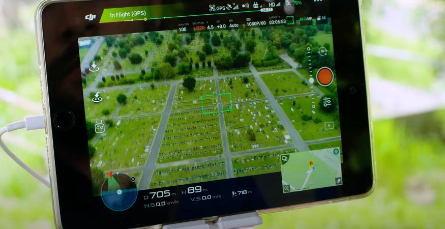
Whether it’s new drone equipment, 360° cameras, GPS equipment, or the most up-to-date GIS software, the benefits we gain from utilising the latest technologies are benefits we can pass on to you.
That ultimately translates to better, more accurate maps that give you greater trust in your inventory.
By being able to more accurately attach data to a true location, we can open up all sorts of opportunities for you to understand and audit your physical location as it relates to your business systems.
That provides massive impact - from identifying inventory you didn’t realise was there, or risk you didn’t know you had.
In all, you’re getting the best mapping tools available, tailored to your needs, backed by a commitment to continual improvement and excellence.
When you partner with PlotBox, you get our team.
Providing worldwide coverage for onsite work using our own team means we can provide the same consistently high standards of mapping and support, no matter where you are.
We will only outsource in exceptional circumstances and to meet specific project demands, using only trusted partners who are subject to a thorough vetting process.
In this way, we can maintain control over the quality of our work, ensuring that it always adheres to the high standards we’re known for.
Customer feedback shapes deathcare provision as we transition to 2024 in the cemetery and crematorium industry.
Master the art of lead generation for cemeteries, crematories, and funeral homes in just 3 steps.
Discover the growing trend of columbaria and vertical structures in the cremation industry, and learn how to maximise pre-need sales opportunities.