Discover how the right tools can revolutionize your cemetery mapping process and improve accuracy and efficiency.
Understanding the Importance of Cemetery Mapping
Cemetery mapping plays a crucial role in preserving the history and heritage of a community. By accurately mapping the layout of cemeteries, important information about the location and arrangement of graves can be documented and preserved for future generations. This information can be invaluable for genealogical research, historical documentation, and maintenance purposes.
Additionally, cemetery mapping allows for the identification of available burial plots and the efficient allocation of space. It helps cemetery administrators and caretakers effectively manage the cemetery's resources and plan for future expansion if needed. By understanding the importance of cemetery mapping, we can ensure the preservation and respectful management of these sacred spaces.
Challenges Faced in Cemetery Mapping
Cemetery mapping can present several challenges that need to be overcome for accurate and comprehensive mapping. One of the main challenges is the sheer size and complexity of many cemeteries. Some cemeteries span large areas with numerous sections, graves, and pathways, making it difficult to create a precise map.
Another challenge is the deterioration and damage of existing graves and tombstones over time. Weathering, vandalism, and natural processes can cause the loss of important information and make it challenging to identify and map graves accurately.
Furthermore, the lack of standardized naming conventions and record-keeping practices can pose challenges in cemetery mapping. Different cemeteries may have unique systems for identifying and documenting graves, making it necessary to adapt mapping techniques accordingly.
Benefits of Using the Right Tools for Cemetery Mapping
Using the right tools for cemetery mapping can greatly enhance the accuracy and efficiency of the process. Specialized software and equipment designed for cemetery mapping provide advanced features and functionalities that simplify the mapping process and improve data accuracy.
These tools can enable precise measurements and georeferencing, allowing for the creation of highly accurate maps. They also facilitate the integration of additional data, such as burial records and photographs, to create comprehensive digital archives.
Furthermore, the use of the right tools can streamline the overall workflow, saving time and resources. Automated features, such as batch processing and data synchronization, eliminate the need for manual data entry and reduce the chances of errors.
Overall, using the right tools for cemetery mapping enhances the quality of the mapping process and ensures the preservation of valuable information for future generations.
Essential Tools for Cemetery Mapping
When undertaking cemetery mapping, there are several essential tools that are necessary for accurate and efficient data collection. These include:
1. Global Positioning System (GPS) devices: GPS devices allow for precise location data collection, ensuring accurate positioning of graves and other cemetery features.
2. Ground-penetrating radar (GPR): GPR technology can help identify buried graves and structures by detecting changes in subsurface materials. This tool is particularly useful for mapping older cemeteries or sites with unknown burial locations.
3. Surveying equipment: Tools such as total stations and laser scanners enable accurate measurements and mapping of cemetery features, including graves, pathways, and boundaries.
4. Digital cameras: High-quality digital cameras are essential for capturing detailed images of tombstones and other features. These images can be used for documentation, research, and preservation purposes.
By utilizing these essential tools, cemetery mapping efforts can be conducted with precision and efficiency, ensuring the creation of accurate and comprehensive maps.
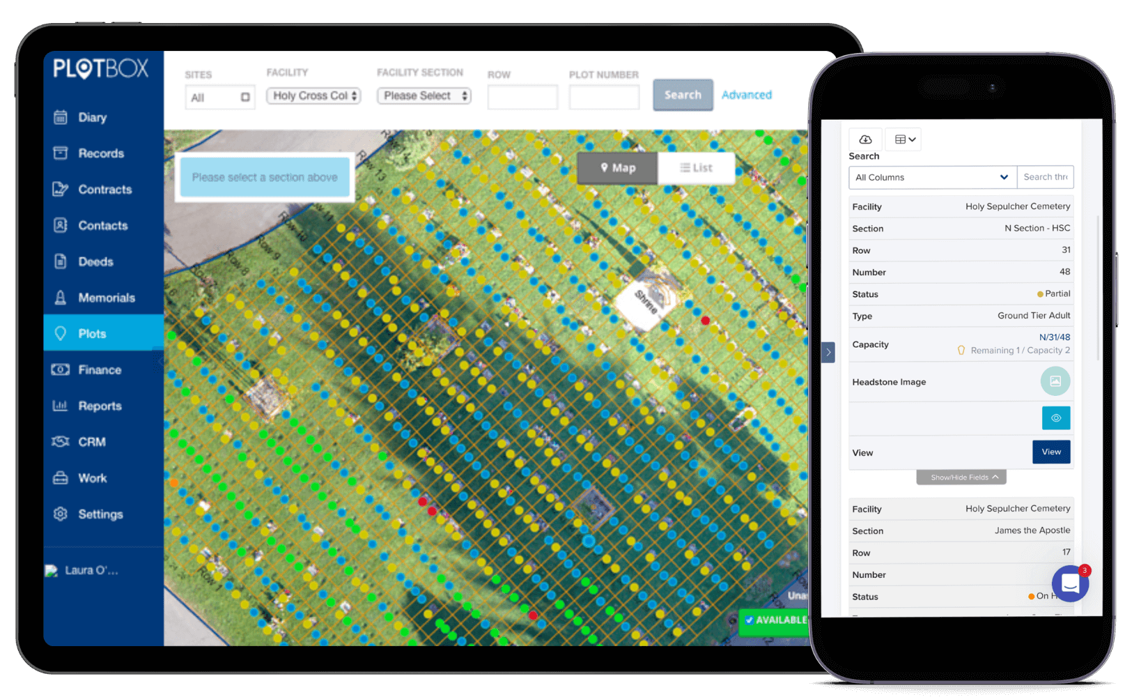
Choosing the Right Cemetery Mapping Software
Selecting the right cemetery mapping software is crucial for a successful mapping project. The software should offer features that meet the specific needs of cemetery mapping, such as:
1. User-friendly interface: The software should have an intuitive interface that allows for easy data entry, editing, and visualization.
2. Compatibility with data formats: The software should support various data formats, including GIS data, burial records, and photographs, ensuring seamless integration and data management.
3. Advanced mapping capabilities: Look for software that provides advanced mapping functionalities, such as georeferencing, spatial analysis, and 3D visualization.
4. Data security and backup: Ensure that the software offers robust data security measures, including encryption and regular backups, to protect the valuable cemetery data.
5. Technical support and training: Consider software that provides reliable technical support and comprehensive training resources to assist users in utilizing the software effectively.
By carefully evaluating and selecting the right cemetery mapping software, you can optimize your mapping process and ensure accurate and efficient results.